

Welcome to Spring and Severe Weather Season
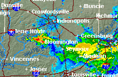 Spring began today at 6:29 AM and Mother Nature wasted no time in kicking things off with a nice Thunderstorm sweeping across central Indiana. While not severe they did issue a "Special Weather Statement" for Owen, Brown and Monroe counties advising that dime size hail was possible.
Todays topic "Severe Weather Outlooks and Watches" is very appropriate and fully described in a document they have written.
Here are a few highlights from their document about what you can do and what NWS partner provides information to help you understand and respond to severe weather events.
- You. Be Weather Ready. Know Your Risk.
- Develop a plan. Encourage others to develop a plan
- National Weather Service
- Issues Hazard Outlooks, identifying weather or flood risks out 7-14 days
- Indiana Department of Homeland Security
- Develops preparedness plans in coordination with local officials
- The American Red Cross
- Alerts trained disaster volunteers to be prepared for possible response
- Schools, Local Safety Officials and Responders
- Monitors NWS Outlooks to determine need for hazard preparations
- The Media
- Local TV meteorologists begin broadcasting concerns for severe weather threats
To view NWS Watches, Warnings and Advisories you can find up to date information here
To view a radar image loop of weather as it develops visit the Indianapolis NWS website for an interactive map
Weather Underground also offers near time radar images and loops on their website
As always stay alert to changing weather conditions and consider loading up a Weather app on your phone, many are free and it could be that your wireless provider is already supplying information to your phone.
 You can read the full story here to see if your wireless provider has this feature